For those who’ve missed our previous installments of MST in a Day:
The 1,175-mile Mountains-to-Sea Trail turns 40 this year — on Sept. 9, to be exact. To commemorate the date and to promote the trail and to hasten its completion (about 680 miles are complete, the remainder is temporarily routed on roads), the Friends of the Mountains-to-Sea Trail is trying to get boots (or paddles) on all 1,175 miles of the trail on Sept. 9. To do so, they’ve divided the trail into 300 legs; as of Aug. 30, 10 days before the Mountains-to-Sea Trail in a Day event, all but 20 legs have hikers. That should get you up to speed.
So yes, all but 20 legs of the trail have at least one hiker/paddler who has pledged to be on the trail on Sept. 9. If you aren’t one of the 982 hikers who have signed up to be part of MST in a Day, here’s how you can participate. Or rather, where you can participate:
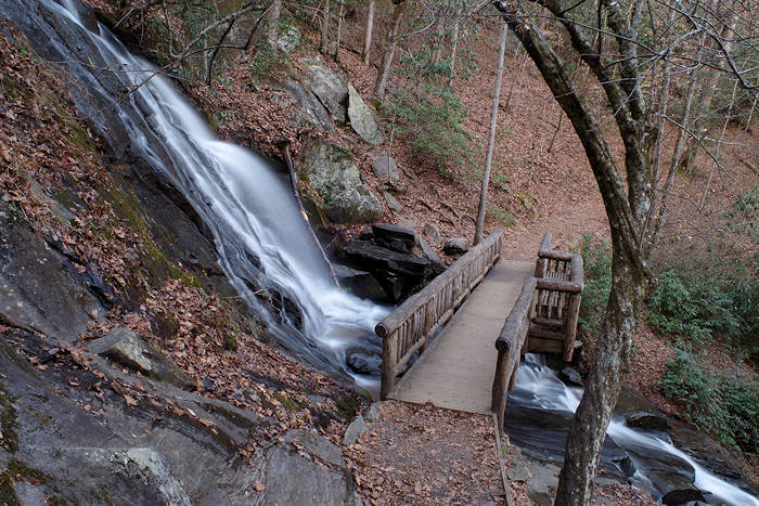
Section 1B: Great Smoky Mountains
7 Legs
So why have people not signed up for seven stretches of trail in the Smokies, of all places? For one, only Leg 1 is actual hiking trail; the other six are temporarily routed on paved roads. And there’s a slight hitch to Leg 1: because it doesn’t begin from a road crossing, you need to hike from the end to the beginning, then back, a total of 12 miles. But that’s 12 miles on the gorgeous Deep Creek Trail, which chums along with its burbly namesake creek. Also: the last six miles are downhill — easy peasy. Who’s in?
Legs 2-7: Yes, this 24-mile run — divvied into legs of 3.0 to 4.6 miles — is on paved road, but mostly on relatively gentle paved road that weaves through the surrounding Smokies and spends a goodly amount of time along the Tuckaseegee River. And, you get to go through some cool mountain towns, including Bryson City, Dillsboro and Sylva. Our thought: sounds like a nice training run for a Saturday morning, no?
Intrigued, aren’t you? Go here for more information and to sign up.
Section 14B: Land of History: Singletary Lake State Park to Holly Shelter Game Land
9 legs
“Land of History” — that right there makes you want to don your Dora the Explorer backpack and learn what you can learn, right? Here’s what you’ll discover on the remaining open legs (all of which are paved, but again, on country roads).
Leg 1, 2.7 miles. You start in Singletary Lake State Park, a park you likely haven’t been to, and a park where European settlement dates back to 1729. Also host to one of the mysterious Carolina bay lakes.
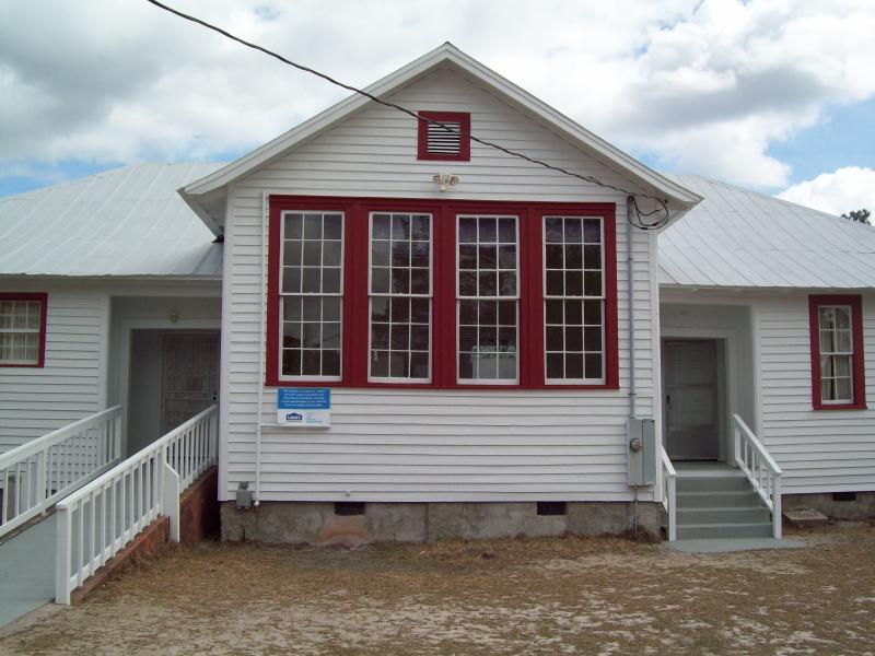
Legs 7-8, 5.3 miles total. Start at the Canetuck Community Center, one of the old Rosenwald Schools that educated African Americans throughout the South for much of the early 1900s.
Legs 10-12, 1.6, 4.5, 3.3 miles. Includes the Moores Creek National Battlefield, Patriots Hall, the History and Tarheel trails (both carpeted with cushy tire fragments) Moores Creek and the Ya-Ya Mini Mart.
Legs 14-15, 4.1, 1.4. Start at the New Hope Missionary Baptist Church, end at the Pender County Museum, where you’ll get a feel for life hereabouts a century ago.
To sign up for some historic hiking, go here.
Section 11A: The Neuse River
4 legs
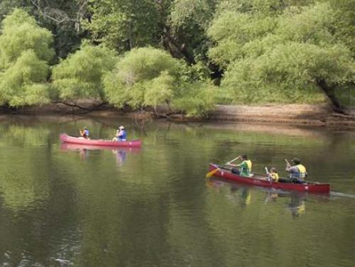
Yes, the MST embraces paddlers, with a 227-mile paddle option on the Neuse River, from the base of Falls Lake dam to the Pine Cliff Recreation Area below New Bern. Check out these legs:
Leg 8, 11.5 miles. Put in in Goldsboro at Old Waynesborough Park, take out at NC 111 and enjoy a Huck Finnesque float in between.
Leg 9, 6.6 miles. It’s nice to have a unique objective on a river trip. On this run, you’ll end beneath an oddity for the Coastal Plain: a 100-foot bluff towering over the river at Cliffs of the Neuse State Park.
Leg 11, 6.8 miles. You’ll pass a little farmland, navigate through a little forest, and have your choice of sandbars to break for lunch or a quick dip (or both, but the former before the latter; otherwise, please wait 30 minutes before dipping).
Leg 12, 16.6 miles. Why so long? Because there’s no access in between, which translates to a day of quiet on the water. Ah.
Get your Old Town out of storage, then head here to claim your stretch of the river.
What say, folks: how about we get those legs filled by week’s end!